Returning the Napa river to its natural floodplain requires a creative blend of ecology and engineering. Once an integral part of the river, floodplains will be re-established at two levels to aid the passage of flood waters. A dry bypass allows raging flood waters to safely shortcut the oxbow, returning only when the river subsides. Yet, to ensure 100-year flood protection, the project also includes new levees, dikes, culverts, bridge replacements, and flood-walls in the most vulnerable areas.
Acknowledging the river’s natural state, the Project utilizes a set of living river strategies that minimize the disruption and alteration of the river habitat, and maximize the opportunities for environmental restoration and enhancement throughout the Watershed. As defined by the Citizens for Napa River Flood Management, “A living Napa River would consist of a river system with structure, function, and diversity. It would have the physical, chemical, and biological components that function together to produce complex, diverse communities of people, plants, and animals.”
A living Napa River:
- Conveys variable flows and restores habitat in the floodplain;
- Balances sediment input with sediment transport;
- Provides natural fish and wildlife habitat;
- Maintains high water quality and supply;
- Offers improved recreation opportunities;
- Maintains its aesthetic-qualities; and
- Generally enhances the human environment.
The approach of The project is based on the natural processes and characteristics of the Napa River itself, incorporating the following principles of geomorphology:
- Maintaining the natural slope of the river-the slope should not be altered significantly by dredging or straightening;
- Maintaining the natural width of the river;
- Maintaining the natural width/depth ratio of the river;
- Maintaining or restoring the connection of the river to the floodplain;
- Maintaining channel features such as mud flats, shallows, sandbars, and a naturally uneven bottom; and
- Maintaining a continuous fish and riparian corridor along the river.
To achieve 100-year flood protection while maintaining the living river principles, the Project design includes the following engineered components:
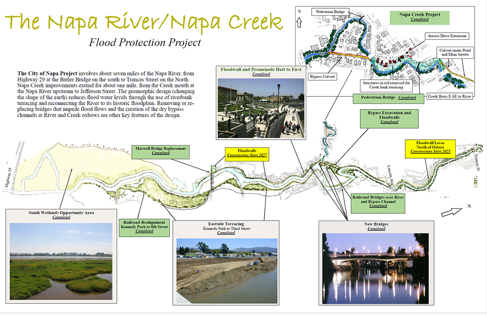
The City of Napa Project involves about seven miles of the Napa River, from
Highway 29 at the Butler Bridge on the south to Trancas Street on the North.
Napa Creek improvements extend for about one mile, from the Creek mouth at
the Napa River upstream to Jefferson Street. The geomorphic design (changing
the shape of the earth) reduces flood water levels through the use of riverbank
terracing and reconnecting the River to its historic floodplain. Removing or replacing
bridges that impede flood flows and the creation of the dry bypass
channels at River and Creek oxbows are other key features of the design.
- Lowering of old dikes;
- Marsh plain and floodplain terraces;
- Oxbow dry bypass;
- Napa Creek floodplain terrace;
- Upstream and downstream dry bypass culverts along Napa Creek;
- New dikes, levees, and flood-walls;
- Bank stabilization and protection (including a grade control structure);
- Bridge replacements
Living River Objectives: “A Living Napa River,” by Karen Rippey, from the June 2000 River Focus, Friends of the Napa River Newsletter
View/Download PDF | Visit the Napa County, Napa River/Creek Flood Protection Project website
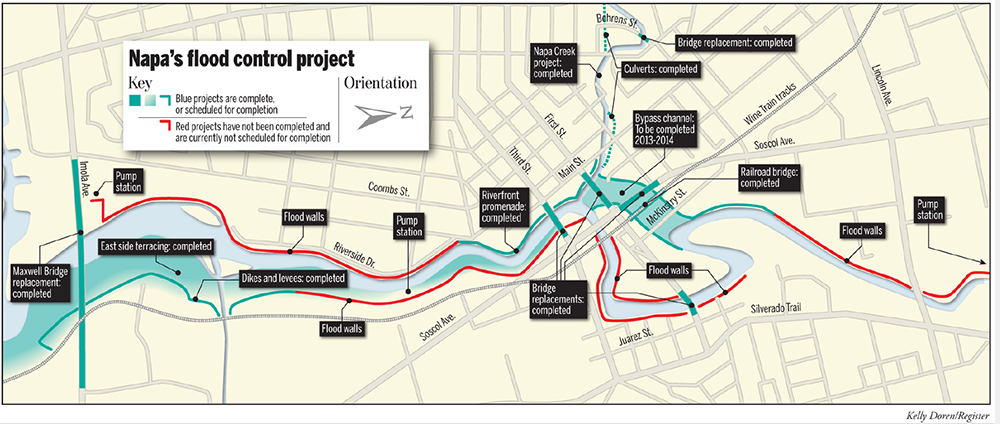
Napa’s Flood Control Project, illustration by Kelly Doren/Napa Valley Register
“The Napa River Flood Protection Project: Creating Floor Protecting and Restoring Geomorphic and Biological Processes,” Jeremy Sarrow, Napa County Flood Control & Water Conservation District, June 2, 2014. (25 page pdf)